|
To
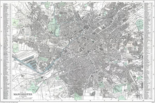
increase the clarity of the map I have removed some stains (which
looked like Lily pollen) as well as reducing the hue of the colour
washes. I think that the plate used to make this version had been
substantially reworked. There are some faint structures which look like
ghosting from an earlier map and random speckling, particularly in the
centre streets. Some of which could be name changes.
Bacon's maps are rarely dated, usually being called "up-to-date" or
"new". Often this meant the latest, most high profile, features were
added but the whole area may not have been updated. Planned, but not built, features were regularly added before completion.
The Manchester Ship Canal was built between 1887 and 1893 and opened in
1894.
Throstle Nest Farm is shown on the map. Manchester United built their
football ground here in 1909 and were defeated by Liverpool in the
first game in February 1910.
Manchester County Cricket Club ground (where they had been since 1857)
is shown surrounded by other clubs' grounds. This became the Manchester
and Lancashire County Cricket Club in 1880 and a number of buildings
were erected in 1884 with the large mid-wicket Pavilion completed in
1895 (not shown).
Exchange Station was opened in 1884 and is shown on the map.
Further information kindly provided by Andrew Andison narrows down the date of the most recent updates to between about 1898 and 1903, as follows
1900 Salford Barracks (Regent Road south side) sold and redeveloped as streets of housing not long after. (shown on the map as Barracks)
1903 Midland Hotel, begun in 1898, opened just north of Central Station. (shown on the map)
1905 Manchester Ship Canal Dock 5 filled in. (shown open as Ordsall Dock)
1907 Botanical Gardens in Chester Road (shown) re-opens as White City Amusement Park.
1908 Royal Infirmary and Mental Asylum demolished, creating Piccadilly Gardens. (the buildings are still shown)
1910 Old Trafford Stadium opened, as did Mayfield Station next door to London Road Station. (neither shown)
|


![]()
![]()